Dublin Core
Title
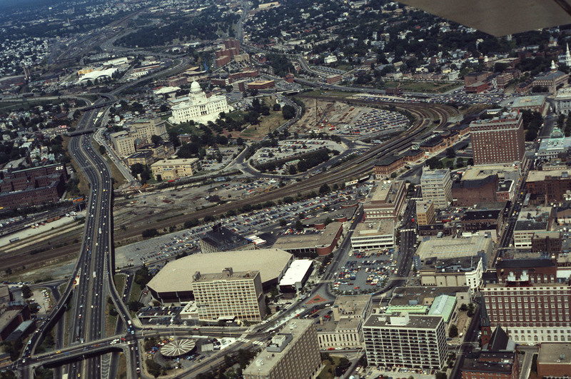
I-95, Providence Civic Center, Capital Center (1983)
Description
Here we see how the former Chinese Wall of train tracks had prevented the downtown development from reaching the capital. The center of the city is essentially a parking lot along the parameter of the downtown financial district. What we see is the future development of the Capital Center.
Creator
Chester Smolski
Source
Leazes, Fancis J. and Mark T. Motte, Providence, the Renaissance city (Boston: Northeastern University Press, 2004), 115-123. Describes the development of the Capital Center Plan into the River Relocation Plan by William Warner in 1984.
Date
1983-01-01
Rights
Rhode Island College
Format
Photograph
Photograph
Identifier
5116
Smolski Image Item Type Metadata
Building Style
Modernism
Building Type
Highway
City
Providence
Country
United States of America
Library of Congress Subject Headings
Aerial photography in city planning -- Rhode Island -- Providence; Urban renewal -- Rhode Island -- Providence; Urban transportation -- Rhode Island -- Providence; City planning -- Rhode Island -- Providence; Land use, Urban -- Rhode Island -- Providence; United States Highway 95 (Rhode Island); Capital Center (Providence, R.I.); Providence, R.I. -- Buildings, structures, etc.; Providence Place Mall (Providence, R.I.) Rhode Island State House (Providence, R.I.); Waterplace Park (Providence, R.I.); Dunkin Donuts Center (Providence, R.I.)
Region
Rhode Island
Theme
Urban Development
