Dublin Core
Title
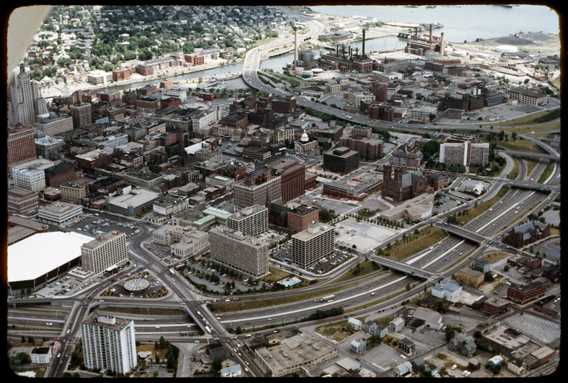
Downtown Providence
Description
Aerial view looking west by southwest. I-95 junction with I-195. In the 2000s I-195 was relocated to the south to allow for development and to correct safety issues and that were the result of poor planning. The Providence Civic Center (Dunkin Donuts Center), which had opened four years earlier is seen in lower left. Buildings in this photograph that have since been demolished include the circular Gulf station, the old police station, The Outlet Company (where Johnson & Wales downtown campus now stands), the Crown Hotel adjacent to it. Vacant space on Green St. is now occupied by apartments at 4 Cathedral Square. Empty lot at 280 Washington Street became Grace Church Apartments.
Creator
Chester Smolski
Date
1976-01-01
Rights
Rhode Island College
Format
Photograph
Photograph
Identifier
5139
Smolski Image Item Type Metadata
City
Providence
Country
United States of America
Library of Congress Subject Headings
Aerial photography in land use -- Rhode Island-- Providence; Urban renewal-- Rhode Island-- Providence; ; City planning-- Rhode Island-- Providence; Land use, Urban-- Rhode Island-- Providence; United States Highway 95 (Providence, R.I.); United States Highway 195 (Providence, R.I.); Providence, R.I. (Buildings, structures, etc.); Urban Development -- Rhode Island -- Providence;
Notes
Chet Smolski, “Downtown Providence,” Rhode Island College Special Collections, accessed November 2, 2015, http://ricdigitalcommons.com/SpecialCollections/admin/items/show/2067.
Region
Rhode Island
Theme
Urban Geography
